A long time ago...
By nature, the Belgian coast evolves towards a dynamic equilibrium between two states, one in which the tidal influence is weak enough for a peat bog to develop, and one in which the sea can penetrate further inland via large tidal channels. Five thousand years ago, the average sea level rise reached a similar level to that at the beginning of the 20th century. The rise in sea level was then sufficiently slow to allow the growth of marsh vegetation and thus the formation of peat.
There is little evidence for any meaningful human activity in the coastal region up to about 2,500 years ago. From the Iron Age onwards, the human presence in this coastal landscape becomes tangible. Around the same time, the sea also started re-entering the coastal landscape and the tidal channel separating the Testerep island from the mainland may have come into existence. This channel was connected to the river Yzer in the west and to the sea in the east, seaward of present-day Ostend.
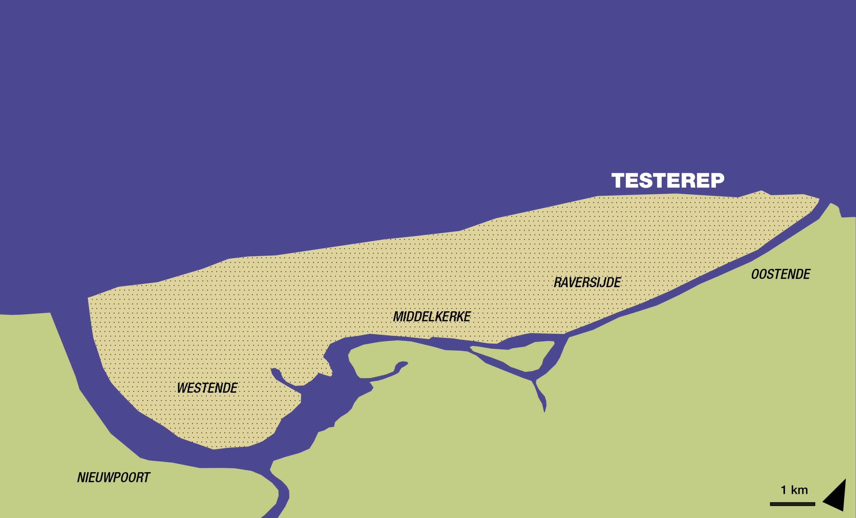
A tentative reconstruction map of the Testerep peninsula and channel. ©VLIZ
During Roman times, peat and salt were extracted in the area and we see the first indications of dike building. Rising sea levels and the collapse of the Roman economy subsequently degraded this coastal landscape, which once again came under the influence of the tides. During the early Middle Ages, sheep farmers gradually resettled in the slowly accreting salt marsh area.
From the year 1000 onwards humans systematically reduced the influence of the sea by constructing dikes. The Testerep channel was eventually dammed and reclaimed as well, in an effort to intensify the exploitation of these wetlands. New settlements - fishing villages like Walraversijde and trading towns like Ostend - were founded. Their residents however were not safe from the rising sea levels. Severe storms and coastal erosion took their toll, leading for example to the flooding and destruction of medieval Ostend which had to be abandoned and resettled further inland.
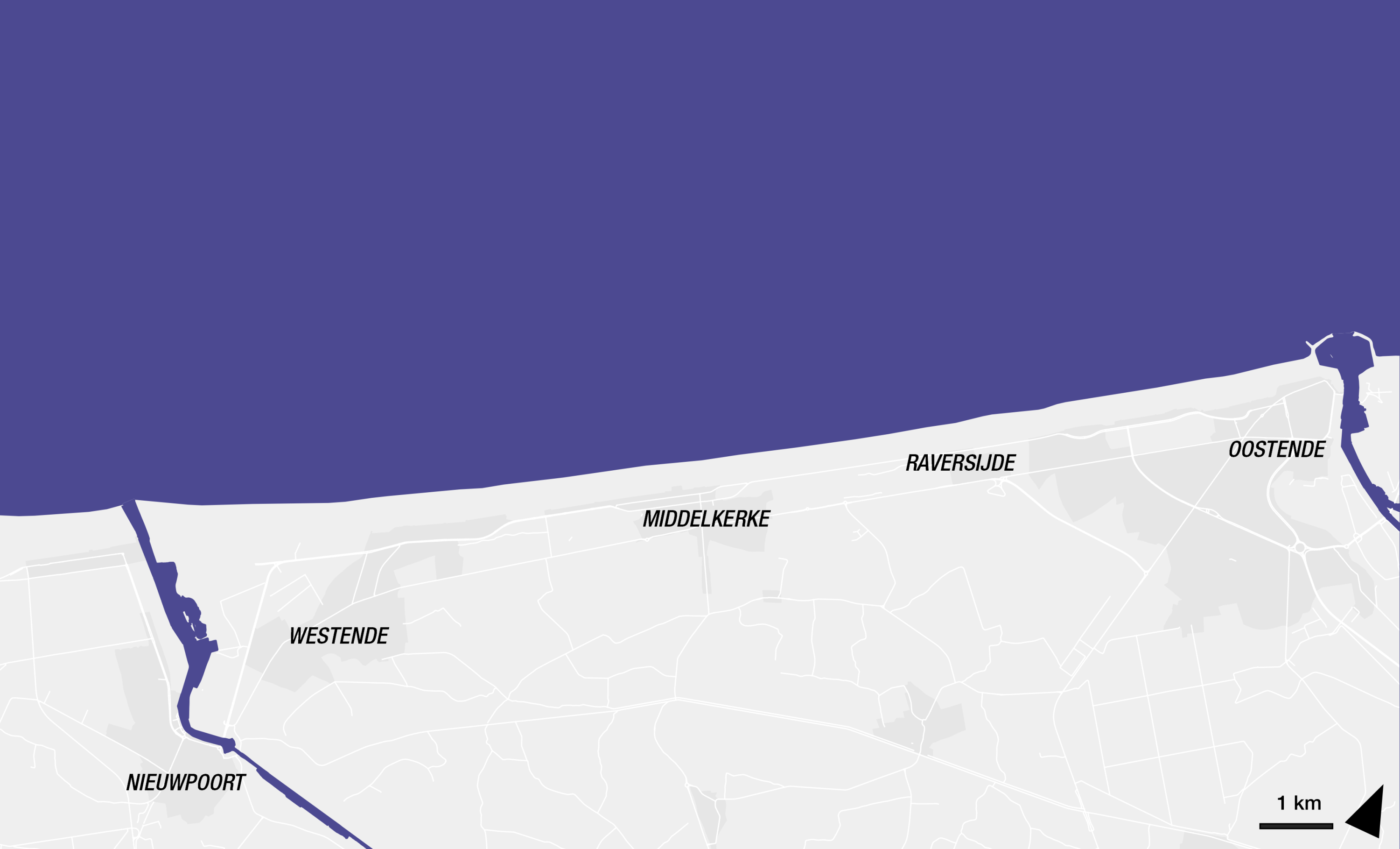
A map of the present-day area where Testerep was once located. ©VLIZ
Increasing investments in coastal defenses from the 17th century onward, and the hardening of the coastline with beachheads and dikes since the 19th century – a practice which was maintained until the 1980s – prevented the coastline from shifting any further inland. Recent decades now see a shift towards 'softer' and more sustainable coastal defenses.
The present-day coastline is therefore a snapshot. Natural phenomena and human interventions have caused continuous changes to the coastal landscape over the past millennia. This will be no different in the coming decades, on the contrary: climate change and more rapidly rising sea levels will impact the appearance of the coast. The precarious future of this fragile landscape makes it necessary to thoroughly understand the interaction between man and nature in the past.
In this summary video, archaeologists from VUB (AMGC – Archaeology, Environmental Changes and Geo-Chemistry Research Group) and marine geologists from VLIZ (Seascapes Past and Future) outline the historical context of the evolution of the Testerep island, explain the scientific research conducted in earlier studies, and present the research objectives of the project. (The video is available in Dutch only.)